

CF-Device specifies GPS for heavy equipment in three tiers rather than one, because it is not a single specification — it splits into three accuracy tiers, and fitting the wrong tier either wastes subscription money on machines that never needed it or leaves a grader unable to work to design. CF-Device’s VCM terminals support standard GPS/BDS/GLONASS as baseline with optional centimetre-level RTK and inertial navigation, so a mixed fleet can specify per machine rather than per fleet.
TL;DR
- Three tiers: standard GNSS (2–5 m), DGPS/SBAS (0.3–1 m), RTK (2–3 cm)
- Only machines whose implement position matters — excavators, graders, piling rigs — need RTK
- Haul trucks and service vehicles work fine on standard GNSS at a fraction of the running cost
- Site conditions break assumptions road-fleet GPS relies on: pit walls, dead zones, constant vibration
- CF-Device VCM terminals: GPS/BDS/GLONASS standard, optional cm-level RTK, IP65–IP67, MIL-STD-810, −30°C to +70°C
The Three Tiers, and Which Machines Belong in Each
The tier a machine needs is determined by one question: does anything physical move to the position the GPS reports? If the answer is no — the fleet office just needs to know where the machine is and how many hours it ran — standard GNSS is sufficient. If a blade, bucket, or pile follows that coordinate, the tolerance collapses from metres to centimetres.
| Tier | Accuracy | Machines | Recurring cost |
|---|---|---|---|
| Standard GNSS | 2–5 m | Haul trucks, loaders, water trucks, service vehicles | None |
| DGPS / SBAS | 0.3–1 m | Dozers on coarse grade, compaction tracking | Low or free (regional) |
| RTK GNSS | 2–3 cm | Excavators, graders, piling rigs, crane placement | Correction subscription or own base station |
In short: pay for RTK on the machines that cut, place, or drive something to a design position — not on the machines that only need to be found.
Why Site GPS Is Harder Than Road Fleet GPS
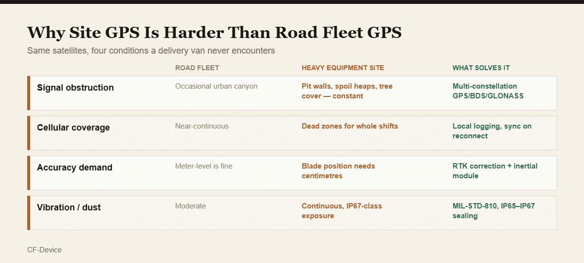
A delivery van and an excavator use the same satellites, but almost none of the surrounding assumptions carry over. Pit walls, spoil heaps, and tree cover block sky view for long stretches; cellular dead zones last whole shifts rather than minutes; and the unit itself absorbs vibration continuously rather than incidentally. CF-Device addresses the first with multi-constellation GPS/BDS/GLONASS reception, the second with local logging and sync-on-reconnect, and the third with MIL-STD-810 vibration certification and IP65–IP67 sealing across the VCM range.
The dead-zone case is the one most often underestimated in procurement. Positioning itself keeps working without cellular — the satellites don’t care — but a system that only streams live data has a permanent hole in the shift record. Why that distinction decides whether utilisation reports are defensible is set out in fleet vehicle GPS tracking systems: the four layers.
What RTK Actually Buys on a Machine
On an excavator or grader, centimetre positioning is not a reporting improvement — it changes what the operator can do without a survey crew. The terminal compares live bucket or blade position against the design surface and displays cut/fill directly, replacing the stop-check-adjust cycle with continuous guidance. CF-Device pairs optional cm-level RTK with an inertial navigation module for exactly this class of work, because machine attitude matters as much as position once an implement is following a design model.
The application detail is covered in excavator slope grading and depth assistance, compaction and blade automation in road roller and bulldozer monitoring, and the correction-source mechanics in our GNSS positioning guide.
Does every machine on a site need RTK?
No, and specifying it fleet-wide is one of the more common budget errors in equipment GPS. RTK carries a recurring correction-service cost per unit, and a haul truck cycling between a pit and a stockpile never uses the precision it pays for. A mixed site typically justifies RTK on 20–40% of machines — the ones with implements following a design surface — while the rest run standard GNSS. Because CF-Device treats RTK as an optional module on the same VCM platform, both tiers share one mounting standard, one 5–36V DC power specification, and one MDM console rather than splitting into two hardware programmes.
A Deployment Example
A civil contractor running 34 machines initially specified RTK across the entire fleet on the reasoning that higher accuracy is never wrong. Reviewing subscription cost after a season showed 19 of those units — haul trucks, water trucks, and service vehicles — had never performed a task requiring better than metre-level positioning. Re-specifying those 19 to standard GNSS cut recurring cost substantially with no measurable change in output, while the 15 excavators, graders, and dozers doing design-surface work continued to justify RTK fully.
Where the Positioning Data Goes
Position is rarely the only thing a site terminal reports. On a CF-Device VCM unit the same install also reads machine data over CAN bus — engine hours, fault codes, hydraulic state — which is what turns a location feed into utilisation and maintenance data. The protocol layer is covered in our CAN bus and J1939 integration guide, the hardware tradeoff between integrated terminals and standalone trackers in fleet GPS tracking hardware, and the mining-specific case in rugged vehicle terminals for mining.
Common Questions
Does GPS keep working underground or in a deep pit?
Not underground — satellites need sky view. In a deep pit, multi-constellation reception maintains a usable fix far more reliably than single-constellation GPS, since more satellites are visible at any given moment.
Can a machine be upgraded from standard GNSS to RTK later?
On terminals designed for optional RTK modules, yes — which is why confirming module support at purchase matters more than the tier initially fitted.
Is an RTK base station better than a correction subscription?
An owned base station removes the recurring fee and works without cellular, which suits a fixed long-term site. A network subscription suits contractors moving between sites frequently.
Which CF-Device models support centimetre-level RTK?
Optional cm-level GNSS and inertial navigation modules are available across the VCM range including the M10, V12, V12 PRO, V10 PRO, and V7 series. The VCM S10-2 PRO additionally supports selectable GNSS modules (MXT906B, UM980, P20E, optional UM982) where a project needs a specific receiver.
Interested in specs or a quote? Contact our team to discuss positioning tiers for your equipment fleet.