

CF-Device supplies the terminal end of agriculture GPS systems, from meter-level tracking to centimetre-level RTK guidance, and the first thing worth saying is that they aren’t one product — they’re a spectrum of positioning accuracy, from basic location tracking to sub-inch guidance, and picking the wrong tier for a given task either wastes money on precision a farm doesn’t need or under-delivers accuracy a task actually requires.
TL;DR
- Agriculture GPS systems range from standard GNSS (2-5m accuracy) to RTK (sub-inch accuracy)
- Correction method — not just the satellite signal — is what actually determines real-world accuracy
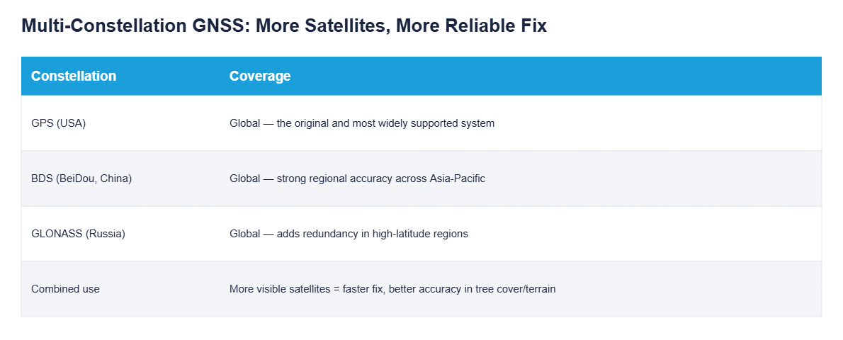
- Multi-constellation support (GPS/BDS/GLONASS) improves fix reliability in terrain and tree cover
- The right accuracy tier depends on the task — auto-steer needs far more precision than fleet tracking
Agriculture GPS Systems Are Accuracy Tiers, Not One Standard
“GPS” in an agricultural context covers a wide range of actual accuracy, and the tier a farm needs depends entirely on the task. Standard GNSS positioning (2-5 meter accuracy) is enough for tracking where a vehicle is; it’s nowhere near tight enough to keep planting rows from overlapping. That gap between “good enough to locate a vehicle” and “good enough to steer it precisely” is the whole reason agriculture GPS systems come in distinct accuracy tiers rather than one universal spec.
Precision Agriculture GPS: What Correction Signals Actually Do
Raw satellite signals alone rarely deliver the accuracy precision agriculture GPS applications need — a correction signal is what closes the gap. DGPS/WAAS corrections (ground or satellite-based reference signals) tighten standard GNSS down to roughly half a meter to a meter; RTK (Real-Time Kinematic) correction, using a local base station or network correction service, tightens that further to sub-inch accuracy. The correction method, not the satellite hardware alone, is what separates a system that’s “good enough for mapping” from one that’s tight enough for auto-steer.
Why Multiple Satellite Constellations Matter
A receiver that only reads GPS satellites is limited to whatever GPS satellites happen to be visible overhead at a given moment — under tree cover, near buildings, or in hilly terrain, that can mean fewer visible satellites and a slower, less reliable fix. Supporting GPS, BDS, and GLONASS simultaneously — the same multi-constellation approach detailed in our GNSS Positioning Explained guide — gives the receiver more satellites to choose from at any given moment, which translates directly into a faster, more stable fix in exactly the terrain conditions where a single-constellation system struggles most.
The Application of GPS in Precision Agriculture Beyond Steering
Auto-steer guidance is the most visible application of GPS in precision agriculture, but positioning data underlies far more of the modern farm operation than steering alone: it’s what timestamps and geo-tags variable-rate application data, what confirms a field pass actually covered the intended area, and what feeds fleet-wide location reporting back to a farm office managing multiple machines across multiple fields at once.
GPS Systems for Heavy Equipment Beyond the Tractor
The same accuracy-tier logic extends past tractors to any GPS system for heavy equipment on a mixed-use farm or contracting operation — graders, sprayers on tracked chassis, and specialty implements all draw from the same GNSS positioning stack rather than requiring separate, incompatible hardware per machine type. Fleet-wide location data from all of it typically converges into the same reporting layer covered in Automated Fleet Management, where positioning becomes one input among several rather than an isolated feature.
Matching the Precision Agriculture Tool to the Task
The practical question for a farm isn’t “which GPS system is best” — it’s which accuracy tier each specific precision agriculture tool on the operation actually needs. Fleet tracking and basic mapping don’t justify RTK’s cost; auto-steer and variable-rate application don’t work reliably without it. For how each accuracy tier translates into measurable field overlap, and which correction source each one depends on, see GPS for agricultural tractors: which accuracy tier your fields actually need. For the full breakdown of what runs on the tractor itself once positioning is in place — guidance displays, implement sensors, and ISOBUS control — see our Precision Agriculture Equipment guide.
A Deployment Example
A grain operation initially equipped its entire fleet with RTK-capable terminals across every machine, including utility trucks that only ever needed basic location tracking for the farm office. Reviewing the setup a season later, the RTK subscription cost on those utility vehicles had never once been used for anything requiring sub-inch accuracy — standard GNSS positioning would have covered their actual task at a fraction of the ongoing correction-service cost, while the tractors doing auto-steer and variable-rate work continued to justify the RTK tier fully.
Common Questions
Does every agriculture GPS system need an ongoing subscription?
RTK correction services typically require a subscription (or a self-owned base station); standard GNSS and many DGPS/WAAS corrections do not.
Can one terminal switch between accuracy tiers for different tasks?
Yes, on hardware supporting optional RTK modules — the same terminal can run standard GNSS for general use and RTK when a task requires it, without separate devices.
Is BDS/GLONASS support necessary outside of China and Russia?
Yes — multi-constellation support improves fix speed and reliability globally, since more visible satellites help regardless of which constellations they belong to.
How much accuracy does variable-rate spraying actually require?
Typically RTK-level (sub-inch to a few inches) accuracy, since zone boundaries in a prescription map can be only a few meters wide.
Interested in specs or a quote? Contact our team to discuss the right GPS accuracy tier for your fleet.